
In search of locations for 70-metre deep holes
In 2021 two special-purpose vessels, Relume and Pioneer scanned a vast area of the North Sea to provide accurate imaging of the seabed – and what lies beneath it. The seabed under the future energy island and a series of new offshore wind turbines was mapped.
Imagine mowing the grass of a giant field using an ordinary lawn mower. Back and forth, back and forth, back and forth in long straight lines until you have mowed the entire field.
Using the same procedure, two vessels are currently scanning some 1,050 square kilometres of the North Sea seabed – an area about twice the size of the island of Bornholm – 80 kilometres off the coast.
The vessels was not just measuring the depth of the sea; they where scanning the subsoil down to 100 metres below the seabed. The purpose is to obtain accurate data about the soil layers. This will give potential tenderers for the contract to install the offshore wind turbines that will surround the future energy island the best impression of what awaits them.
"They need to know whether the seabed is suitable for the foundations of the wind turbines or less suitable, making it more expensive to install the wind turbines", says Jens Colberg-Larsen, Chief Consultant at Energinet’s Environment and Geoscience department, pointing out that the wind turbines could be as tall as the pylons of the Great Belt Bridge, and in order for the 8-10-metre wide wind turbine foundations to be fixed, they may have to be located at a seabed depth of 40-60 metres.
Similar operation at the island of Bornholm in the Baltic Sea
In addition to scanning the subsoil, the vessels where also searching for debris, mines, waste or anything else that could be in the way of later preliminary surveys and the actual wind turbines.
A similar operation has been taking place at the island of Bornholm, designated by the Danish Parliament as Denmark’s second energy island. Here, the plan was to survey some 550 square kilometres of the Baltic Sea seabed to provide the best possible basis for the future offshore wind farm foundations.
Other special-purpose vessels have performed geotechnical surveys. Jack-up vessels that stand on legs on the seabed and drilling 70 metre holes have given us even more knowledge about the nature of the soil layers.
In dialogue with fishermen
Jens Colberg-Larsen explains that the work of mapping the vast area disturbs the fishing vessels with nets in the area.
- But our cooperation with Danish fishermen is good, and we try to coordinate our work with the fishermen in the best way possible. We can make arrangements not to sail where their nets are set on some days – and in return they will fish elsewhere the following week, so we can come back and do our job. We understand and respect that this is their occupation, say Jens Colberg-Larsen.
Figure 1: Graphic representation of seismic measurement data from the North Sea seabed, May 2021. From the vessel Relume.
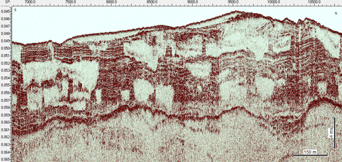
The soil layers below the seabed are mapped using seismic equipment. Seismic equipment transmits sound waves that are ‘stopped’ by soil layers such as boulder clay, rocky layers or soil layers containing gas. Vessels surveying the seabed typically carry two types of seismic equipment. One, as the one in the graphic representation, capable of penetrating soil layers from 3-10 metres below the seabed, and one capable of going deeper than 100 metres below the seabed. Sound waves may harm marine mammals. So, if the vessel crew detect marine mammals in the area, the seismic measurement work is temporarily stopped.
Contact
-
- Thomas Laursen
- tlu@energinet.dk
- +4521807104
The vessels survey
- What the sea depth in the area is – 20, 30, 50 metres?
- What the seabed consists of – solid ground, soft ground, rocky ground?
- Whether the seabed is stable – sand migrations or mobile seabed?
- Whether the seabed is already home to other things – shipwrecks, naval mines, existing pipelines, animal habitats?